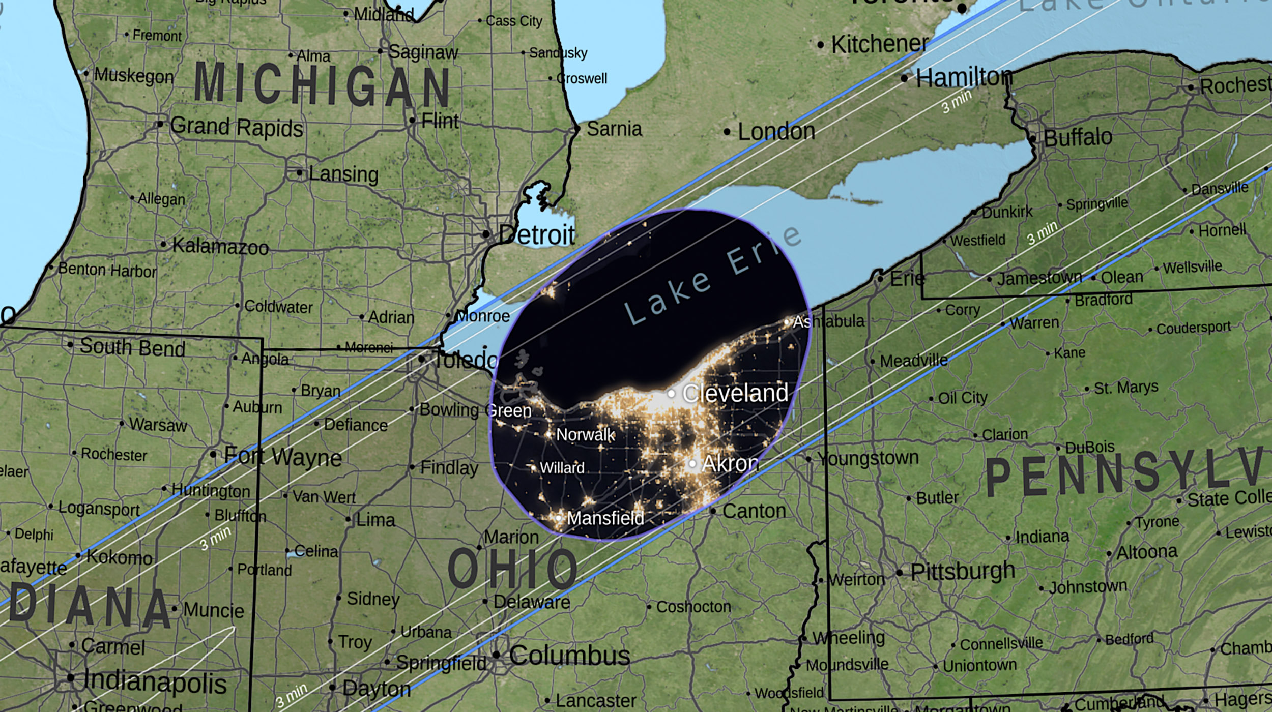
An eclipse map can look deceptively simple: a dark band crossing a bright globe, with a centreline running through it. But the boundary between “total” and “not total” is not drawn by a marker pen. It is the result of a moving three-dimensional shadow, an irregular Moon, an uneven Earth, and an observer whose exact elevation and coordinates matter. Modern maps become accurate by replacing convenient shapes with measured terrain and explicit geometry.
1. The old map was useful because it was simple
For generations, eclipse calculations represented the Moon as a smooth sphere and treated observers as though they were standing at sea level. That simplification is not foolish: it makes the geometry understandable and produces a useful first estimate of where the Moon’s umbra should travel.
The problem appears at the edge of totality. When the Moon’s shadow is sweeping across Earth, a small change in observer elevation or in the shape of the lunar limb can change whether the last bright part of the photosphere disappears at a particular location. A smooth model cannot show those local details because it has deliberately removed them.
“Why does it look like a potato instead of a smooth oval?”— NASA — NASA Develops Process to Create Very Accurate Eclipse Maps
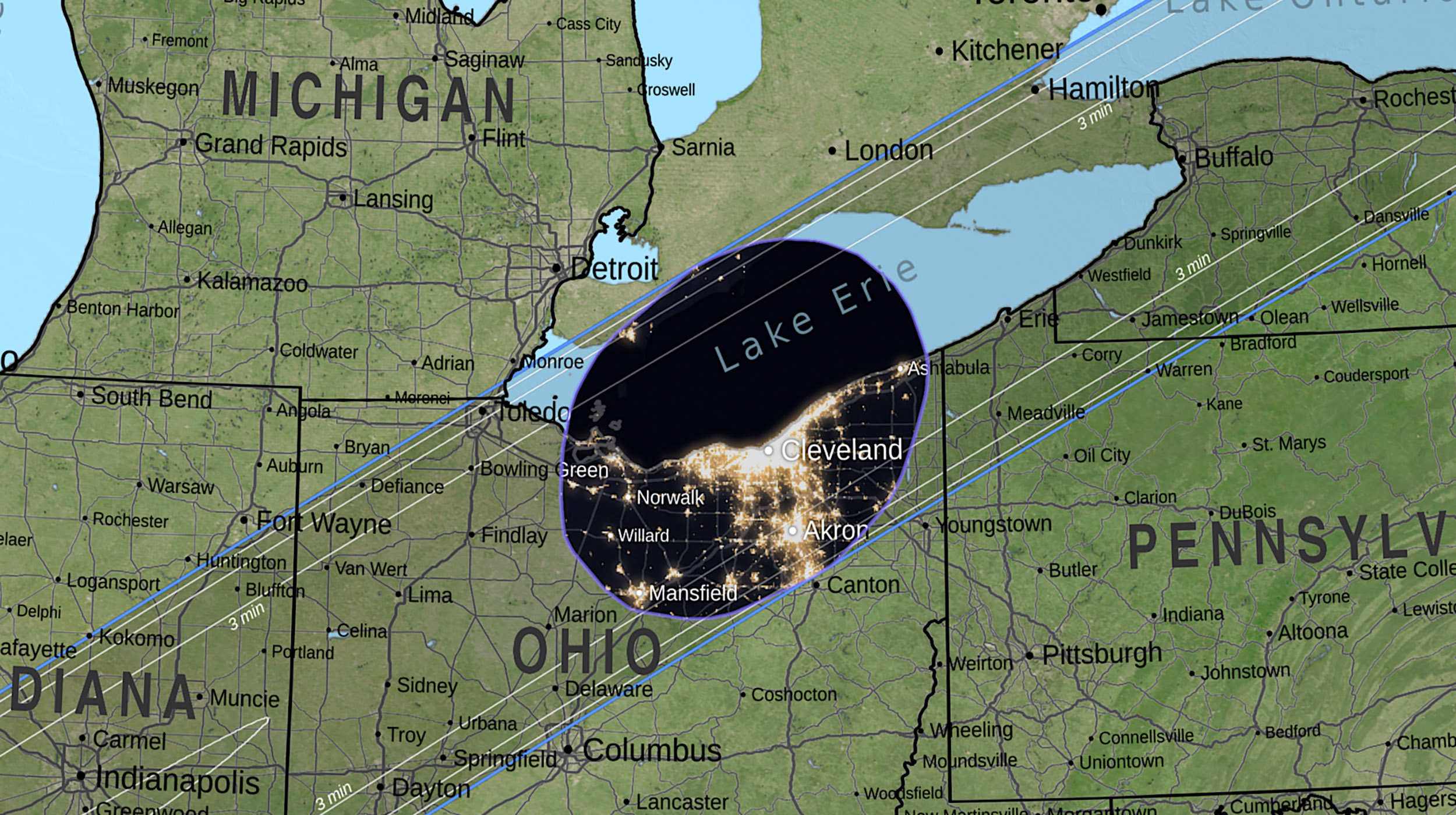
2. Earth is not a flat platform
The observer is not just a latitude and longitude. A valley floor, a plateau, and a mountain ridge occupy different heights above Earth’s reference surface. From the Moon’s perspective, those observers are not in exactly the same geometric relationship to the incoming shadow.
That matters most when a location is close to the edge of the path or when you are trying to understand a marginal result. A few kilometres can change the timing and duration of totality, but so can the height at which the observer is actually standing. This is why a map designed for a broad audience should be treated as a starting region, not as a promise about one field or road.
NASA’s more accurate mapping approach adds Earth elevation so observer locations are represented at their true altitude. SunEclipses applies a different but complementary local question after the eclipse path is selected: what does the terrain around this exact point look like in the direction of the Sun?
- Broad path: identifies the region where totality can occur.
- Observer geometry: refines the event for the chosen coordinates and elevation.
- Local horizon: checks whether ridges, hills, trees, or buildings can block the low Sun.
3. The Moon has mountains and valleys too
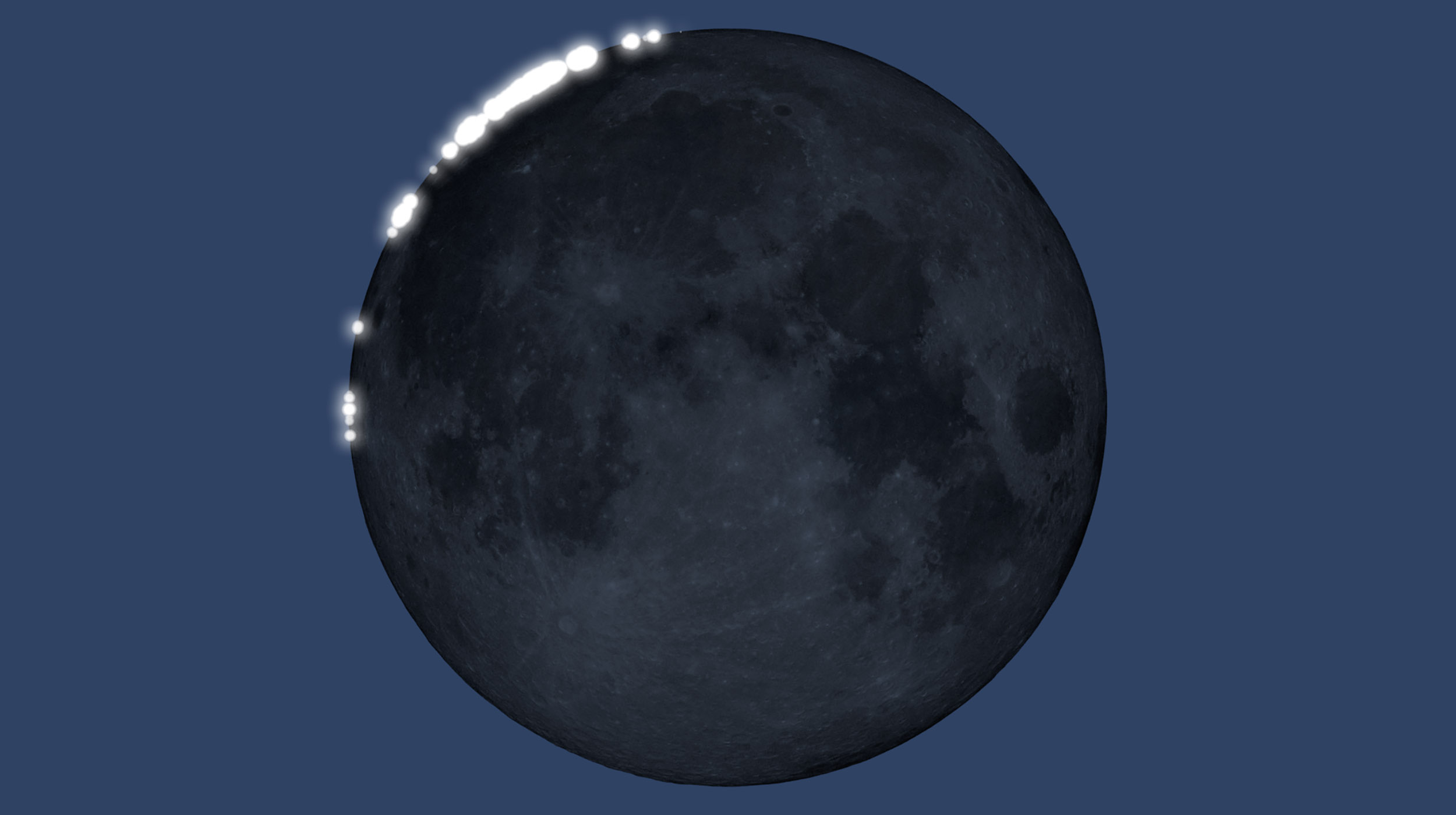
The Moon’s visible edge is not a mathematically smooth circle. Mountains and valleys along the lunar limb allow the last rays of sunlight to pass through in some places while other parts of the photosphere are already hidden. Those small openings produce Baily’s beads and the diamond ring.
The same irregular limb changes the shape of the umbra on Earth. NASA’s Lunar Reconnaissance Orbiter has measured lunar elevation in enough detail to replace the smooth-limb assumption with a continuously varying profile. The result is a shadow that can look flower-like or potato-shaped, because the boundary is built from the real geometry of lunar terrain rather than from a perfect ellipse.
“The Moon’s terrain impacts our view of the total solar eclipse.”— NASA — Lunar Activities: Lunar Topography
4. Baily’s beads turn topography into a visible clock
Baily’s beads are not separate objects travelling around the Sun. They are brief points of photosphere light shining through low places along the Moon’s edge. As the Moon moves, one valley closes while another may remain open, so the beads appear, merge, and vanish in a rapid sequence.
For an observer, this is beautiful. For a mapmaker, it is also information. The timing and position of those flashes depend on lunar shape, solar geometry, observer location, and elevation. Accurate lunar topography makes it possible to model the sequence more precisely than a smooth Moon allows.
Safety remains non-negotiable: during the partial phases, filters stay in place. For optical equipment, use a proper front-mounted solar filter and follow the equipment maker’s instructions. Direct unaided viewing without filters belongs only inside totality, after the bright photosphere has completely disappeared and before it returns.
- Before C2: keep solar viewers and optical filters on.
- At the final bead: totality begins only when the bright photosphere is fully hidden.
- At C3: replace filters before the returning photosphere enters your view or optics.
5. Modern maps are rendered, not merely sketched
NASA describes the newer method as rendering the eclipse one pixel at a time, similar to the way complex computer visualizations are built from many small elements. Each pixel can account for the relationship between the Sun, the Moon’s irregular limb, Earth’s surface, and the moment being displayed.
That approach makes the map more truthful, but it also makes the result more honest about complexity. The boundary is not a single immutable line. It changes with time, location, elevation, and the definition of the visibility question being asked. A centreline is useful for orientation; it is not the only place where totality occurs, and it is not a substitute for checking your own coordinates.
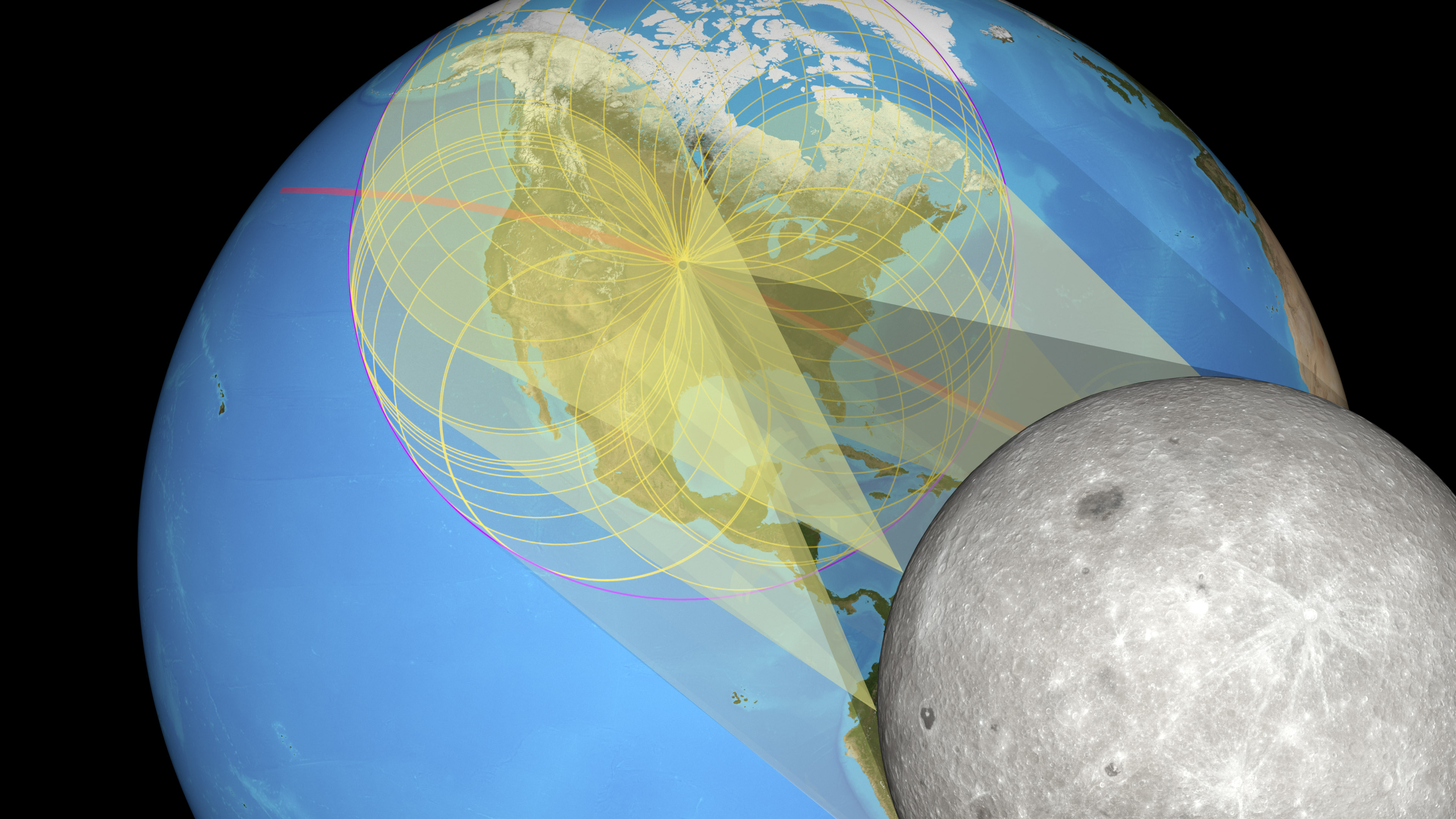
6. What SunEclipses adds after the path map
The path of totality answers one question: can the Moon’s umbra reach this region? A viewing planner has to answer another: can I actually see the eclipsed Sun from this point when it matters?
SunEclipses combines observer coordinates with event timing, a global digital-elevation model, and a horizon profile sampled around the location. The purpose is not to pretend that a terrain model is the same thing as a live photograph. It is to expose the terrain signal behind a recommendation: which direction is relevant, how high the modelled horizon rises, what data source and resolution were used, and where the result is marginal.
For the 12 August 2026 eclipse, this distinction is especially important in Spain. The official NASA event page notes that totality arrives in Spain shortly before sunset, while Spain’s Instituto Geográfico Nacional describes the Sun as close to the horizon. A location inside the path can therefore still fail as a practical viewpoint if a western ridge or building hides the final minutes.
- Start with an official eclipse path and observer-specific contact times.
- Inspect the relevant solar azimuth and elevation for C2, totality, and C3.
- Compare the Sun’s line of sight with the modelled terrain horizon.
- Treat buildings, trees, atmospheric refraction, local relief, and weather as reasons to verify marginal results on site.
7. Accuracy does not mean certainty
A more accurate map reduces one kind of uncertainty: the uncertainty created by simplifying the Moon and Earth. It does not remove clouds, construction, vegetation, access restrictions, atmospheric conditions, inaccurate coordinates, or a ridge that is missing from a coarse elevation grid.
The right way to read a model is therefore as evidence with provenance. Ask what geometry it represents, what terrain dataset it uses, what resolution it has, what it leaves out, and whether the result is comfortably clear or only barely clear. A transparent limitation is more useful than a confident-looking score with no explanation.
The final check is physical. Visit early if you can, face the correct horizon, identify the safest accessible spot, and keep a nearby backup. The map can tell you where to investigate. Your eyes, the weather, and the actual landscape decide what happens on eclipse day.
“The only safe way to look directly at the uneclipsed, partially eclipsed, or annularly eclipsed Sun is through special-purpose solar filters.”— AAS — How to View a Solar Eclipse Safely